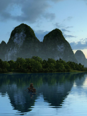


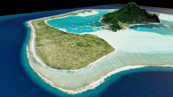
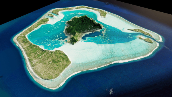
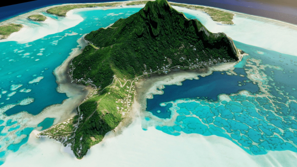
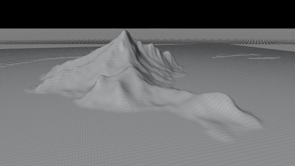
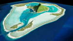
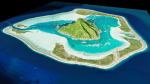
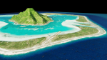

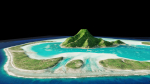

maupiti island 3d model terrain
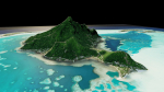
maupiti island 3d model terrain
Product details
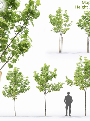
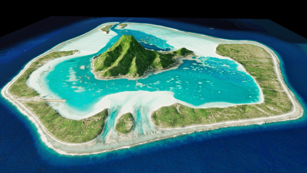
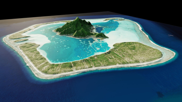
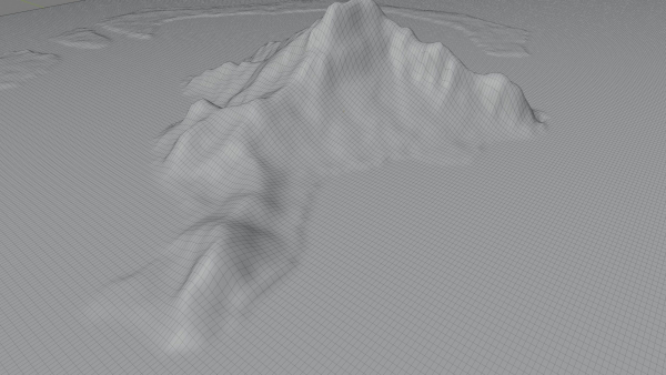
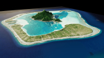
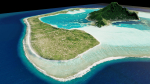
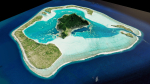
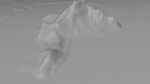
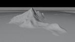
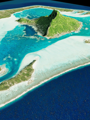
French Polynesia island of maupiti 3d model terrain. 3d model landscape of the island of maupiti with its landscape of mountains, beaches and forests French Polynesia island of maupiti 3d model, Leeward Islands, French Polynesia, France High Poly mesh High detailed model with 4K textures Diffuse map AO map -Displacement map -Normal map -Roughness map The Blend file do not require the displacement, but you can still use it if you want to create other island model yourself texture example from the Maupiti Island, Leeward Islands, French Polynesia, France. Maupiti is an island in the western Leeward Islands in French Polynesia. It is the westernmost volcanic island in the archipelago, 315 kilometres northwest of Tahiti and 40 kilometres west of Bora Bora. It has a population of 1,286 people. The largest town is Vaiea.
Shipping and Returns
Shipping cost is based on weight. Just add products to your cart and use the Shipping Calculator to see the shipping price.
We want you to be 100% satisfied with your purchase. Items can be returned or exchanged within 30 days of delivery.
Quick Comparison
| Settings | maupiti island 3d model terrain remove | Red Desert Pack remove | Scottish Highland with grass and moss remove | vertical plant set 185 remove | Vegetation 2 - Asset Pack by ithappy remove | Wasteland Mountain Landscape remove |
|---|---|---|---|---|---|---|
| Name | maupiti island 3d model terrain remove | Red Desert Pack remove | Scottish Highland with grass and moss remove | vertical plant set 185 remove | Vegetation 2 - Asset Pack by ithappy remove | Wasteland Mountain Landscape remove |
| Image |  | 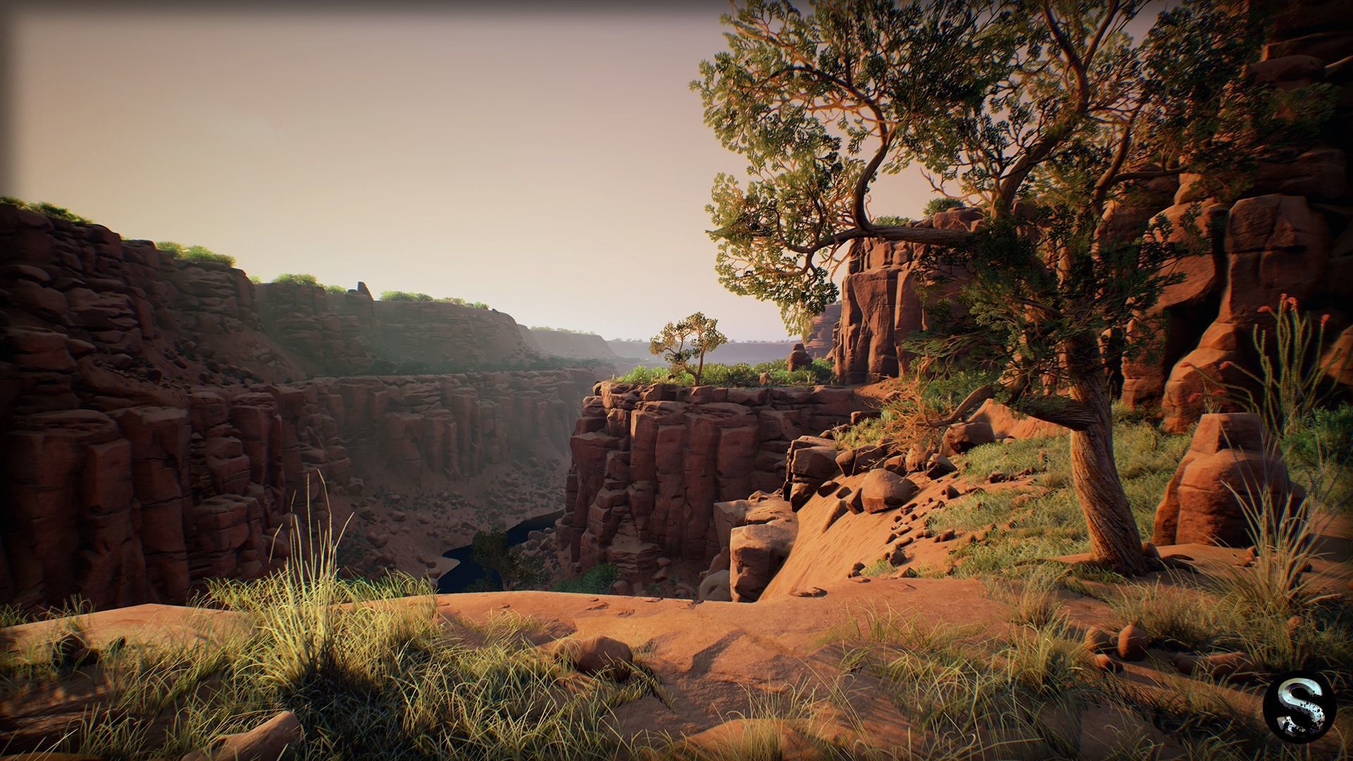 | 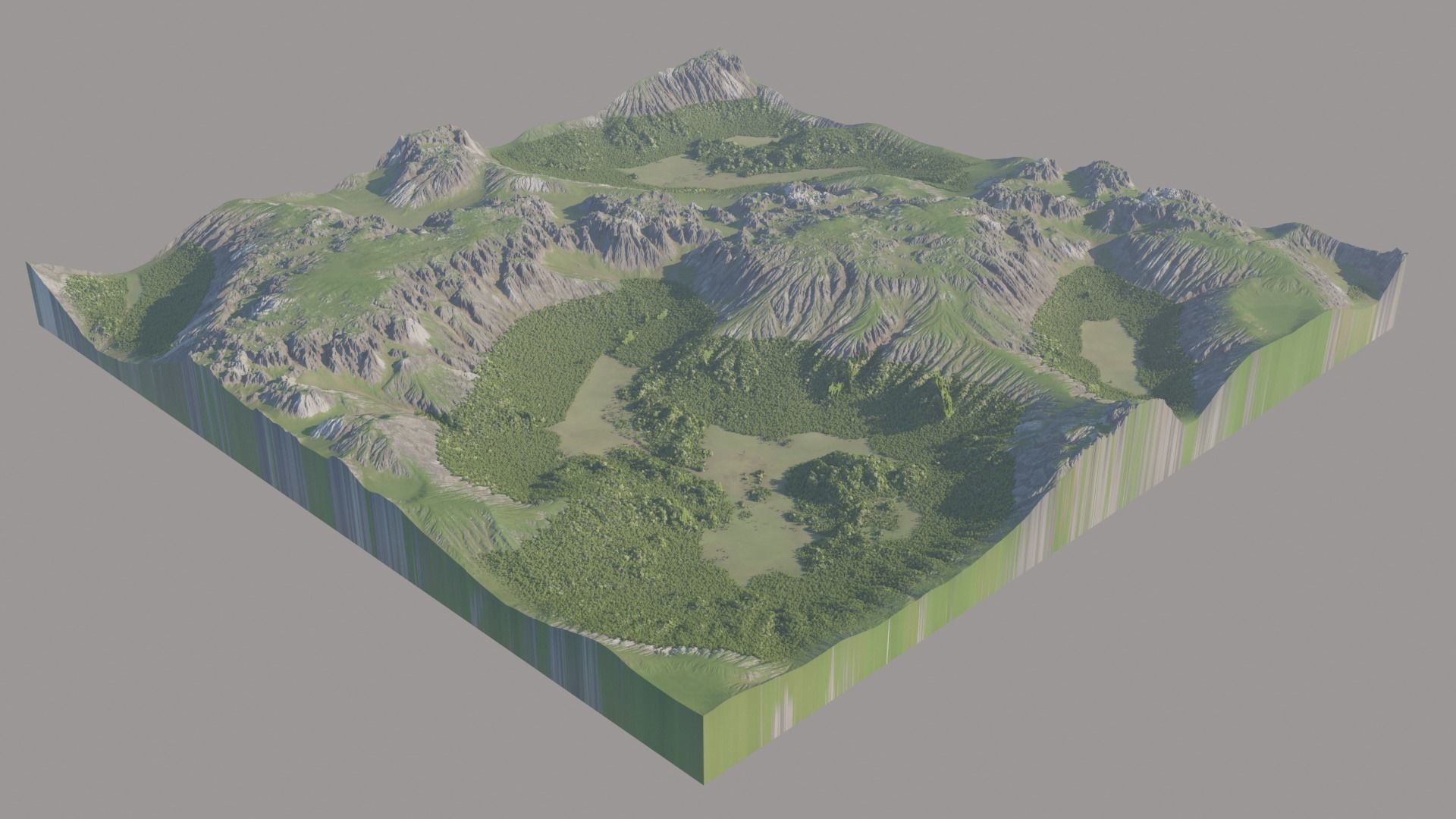 |  | 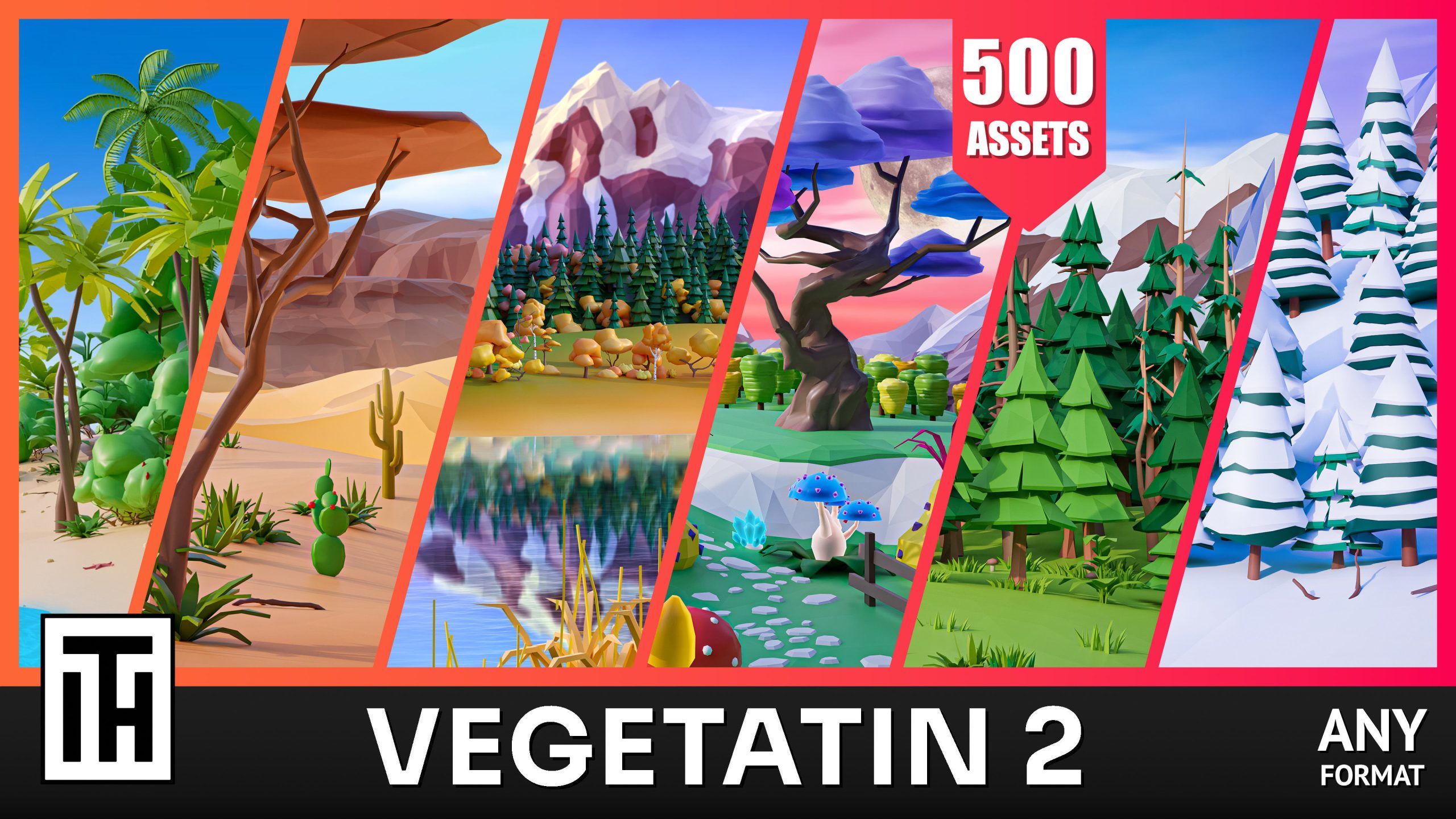 | 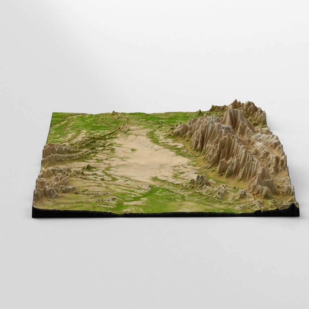 |
| SKU | 4725456 | 4517403 | 1893583 | 3537901 | 4497689 | 2114218 |
| Rating | ||||||
| Price | $5.00 | $80.00 | $25.00 | $7.00 | $79.00 | $10.00 |
| Stock | ||||||
| Availability | ||||||
| Add to cart | ||||||
| Description | ||||||
| Content | French Polynesia island of maupiti 3d model terrain. 3d model landscape of the island of maupiti with its landscape of mountains, beaches and forests French Polynesia island of maupiti 3d model, Leeward Islands, French Polynesia, France High Poly mesh High detailed model with 4K textures Diffuse map AO map -Displacement map -Normal map -Roughness map The Blend file do not require the displacement, but you can still use it if you want to create other island model yourself texture example from the Maupiti Island, Leeward Islands, French Polynesia, France. Maupiti is an island in the western Leeward Islands in French Polynesia. It is the westernmost volcanic island in the archipelago, 315 kilometres northwest of Tahiti and 40 kilometres west of Bora Bora. It has a population of 1,286 people. The largest town is Vaiea. | Package high quality nature. Pak is ideal for the creation of a post apocalyptic or Wild West game. Desert plants that grow in Arizona and Mexico (Cholla, JoshuaTree, MurphysAgave, Opuntia, Saguaro, etc.) Attention ---- This package does not contain a scene for the 3d package, the scene only works on the Unreal engine (the screenshots are made in UE4) Pack includes a fully ready projects on UnrealEngine4 This pack includes: 77 textures Texture Sizes from 8x8 to 4096x4096 75 meshes flora 37 meshes cliff and stone Range of Tris (Min and Max) - 64-36729 tris All meshes have a LOD and Collision | Scottish Highland with grass and moss, hills and mountains. There is a high and a low version of the model in FBX and OBJ format and a 3d max file for you to play with. (trees are not included, these are just for visuals) 8k textures High detailed model Height map Diffuse map Normal map Best used as mid to far-away shots Detail is up to the mesh density you go for ( more polys more details (3dmax displace) ) | Name: vertical_plant_set_185 Version: 2015 Polys: 746192 verts: 1158304 XForm: Yes Model Parts: 16 Render: corona, vray Formats: 3Ds Max 2015, FBX | Сonnect with digital art enthusiasts, and stay up to date on new products, tutorials and more! https://discord.com/invite/jxrQM8hXnd ▲ General ▲ ● You can combine packages together, choose the most suitable ones, making your games unique and distinctive. ● When you purchase models, you receive any available file formats. If you need a format that is not listed, please contact us, and we will let you know if we can prepare it for you. ● We offer services for creating 3D models and developing various custom projects. If you have specific requirements or ideas, contact us, and we will help bring your project to life. ▲ ithappy presents ▲ Vegetation 2 - Low Poly Asset Pack by ithappy Welcome to the world of natural beauty and greenery! Vegetation 2 is a package of low-polygon 3D models optimized for game engines, consisting of 504 assets such as deciduous, coniferous trees, palms, Savannah trees, bushes, fantastic plants and much more! Unlike our other pack Vegetation, there are more models. ▲ Key Features ▲ ● 504 assets that offer limitless possibilities for creating unique locations. ● Pack only includes the vegetation. The package does not include environment scenes. (landscape, mountains, environment). ● Models are optimized for game engines, easily editable and customizable. You can also use them for animations, advertising and marketing, VR/AR, 3D printing. ● Regular updates and support. We aim to improve this package, add new resources, and constantly enhance its content. ▲ Pack Content ▲ 504 models: ● Deciduous trees (x37) Oak, maple, birch, apple tree, etc. ● Coniferous trees (x107) Spruce, pine, fir, cypress, cedar, etc. ● Palms (x24) Twisted, tilted, lots of palm ● Savannah trees (x8) Acacia, dry tree, baobab ● Bushes (x25) Berry bush, lilac, barberry, etc. ● Deadwoods (x56) Log, stick, stump, dead bush, fallen tree, etc. ● Plants (x53) Сactus, reed, water lily, grass, hay, flower, mushroom, etc. ● Fantastic trees (x80) Twisted tree, square tree, spiral tree, swamp tree, scary tree, etc. ● Fantastic mushrooms (x46) Fly agaric, white mushroom, fairy mushroom, huge mushroom, cap mushroom, etc. ● Fantastic deadwoods (x17) Twisted, spiral, scary, fabulous, etc. ● Fantastic plants (x40) Pumpkins, pears, twisted fruit, corals, sunflowers, stars, etc. Don't miss the chance to add natural beauty to your projects with Vegetation 2! This package of 3D models will turn your landscapes into picturesque corners of nature that will attract attention and give joy. Open the doors to the world of natural harmony with Vegetation 2! If you liked this package, please leave a review! Creativity to you! TECHNICAL DETAILS ▲ Geometry 504 unique assets 584k triangles all pack ▲ Scale Real-world-size ▲ Animation Yes ▲ Materials All models use 1 material (color) ▲ Textures All models use 1 texture (color) Resolution: 2048 px ▲ Collision Yes ▲ Files Unreal Engine, Unitypackage, Blender, C4D, Maya, 3DSMax, FBX, OBJ, GLTF, STL | Wasteland Mountain Landscape 3d model made with 3Dmax and Vray. High poly mesh with 2 diffuse maps for different look variations 2000x2000px Texture 3D Max file has color correction on textures and Vray Materials for the final render quality, other file type may have diferent color outputs than the preview renders. |
| Weight | N/A | N/A | N/A | N/A | N/A | N/A |
| Dimensions | N/A | N/A | N/A | N/A | N/A | N/A |
| Additional information | ||||||
| Sold | 0 | 0 | 0 | 0 | 0 | 0 |
| Shipping |